Dominica -- Boiling Lake, Champagne Reef, the Parrot Reserve, and Indian River
Our first big activity in Dominca was a hike to the Boiling Lake. The Boiling Lake is exactly that: a lake with a constant temperature of 84 degrees Celsius (183.5 Farenheit) where the cool water meets the warm. It's a geothermal vent in Dominica's highly active foundation, and it's very impressive. Every 70 years or so, the lake empties back into its crater, and until there is a second seismic shift, no amount of rainfall or drainage will refill it. We saw it in its full glory. The hike itself crosses a significant portion of the Morne Trois Pitons (Three-Peak Mountain) National Park and traverses a lot of ridges and valleys. This is the infamous hike on which I counted the stairs (not the steps) on the way home and came up with 3895. That means we climbed around 8000 stairs in addition to tree roots, boulders, gentle inclines and declines. We can both still feel it a week later!
This is a wooden water pipe that carries water into Dominica's hydroelectric producing stations. This pipe runs throughout the Morne Trois Pitons National Park, and it's always a little surprising.
After about two hours of slogging up and down stairs (more up than down, obviously), you reach the high point on the Boiling Lake trail. It's called Morne Nicholl, and from the top you can see Martinique on a clear day! Martinique is south and slightly east, so you're seeing the Atlantic Ocean in this picture.
You can also see Roseau, the capital of Dominica, on the western side of the island. So, on a clear day you can stand atop Morne Nicholl and see both oceans and some of the prettiest peaks in the country.
The smattering of houses about halfway up this hillside is the town of Laudat. It's the starting point of the hike.
This is the famous Morne Trois Pitons itself (left side of the photo). In front of it and slightly to the left is Morne Micotrin. Ian again provides scale for the picture.
I just really like this photo even if it doesn't contribute to a greater understanding of the natural history of Dominica. I think that's Morne John in the background.
This is a complex jungle hillside. Unfortunately, our camera was overwhelmed by the colors and the brightness, so these pictures are nowhere near as beautiful and vibrant as the real thing. I guess we need filters to help the camera comprehend the intensity of the Caribbean sun!
This is a fern detail in a different complex jungle hillside. There are lots of ferns in Dominica, and I took lots of pictures of them. If anybody is collecting fern photos, let me know and I'll provide more!
This is red ginger lily. It also comes in white and pink, but they're much less common. Ginger lily looks like a beautiful exotic flower to this Oregonian, but it grows like a weed in Dominica!
The moon shows some serious confusion in Dominica. It was out for much of the day the whole time we were there. I took this picture at about 11 AM.
The Boiling Lake as seen from Morne Nicholl.
The trail to the Boiling Lake passes through the Valley of Desolation. This is just above the Valley of Desolation on the descent from Morne Nicholl.
And here's the first view of the Valley of Desolation. What you don't necessarily know from this picture is that the trail goes straight through it, boulders, sulfur springs, boiling water, and all. Our fabulous guide, Jeffrey, kept telling us it was a lot like Yellowstone, and in some ways, of course, he's right. The difference, and we tried to explain this, is that Yellowstone has paths, guard rails, and rules (plus it's a whole lot bigger). Hopefully someday Jeffrey gets to Yellowstone to see for himself how cool it is for foreigners to get to walk right up to the edge of bubbling sulfur pools!
And I do mean right up to the edge.
Swirling sulfurous fumes, spitting sulfurous water, and lots of shaky boulders make for good fun!
There are also several sources of cool, fresh, clean water running through the Valley of Desolation. The tan-colored rocks on the right side of this picture are a fresh, cold stream with few or no extra minerals in the water. The steel-colored rocks and water on the left are a mineral-rich (hematite, perhaps), hot stream coming down from a sulfur vent.
This is looking back up the Valley of Desolation on our way to the Boiling Lake. All those boulders do not count in the 4000 stairs statistic. It was really beautiful, for all my complaining!
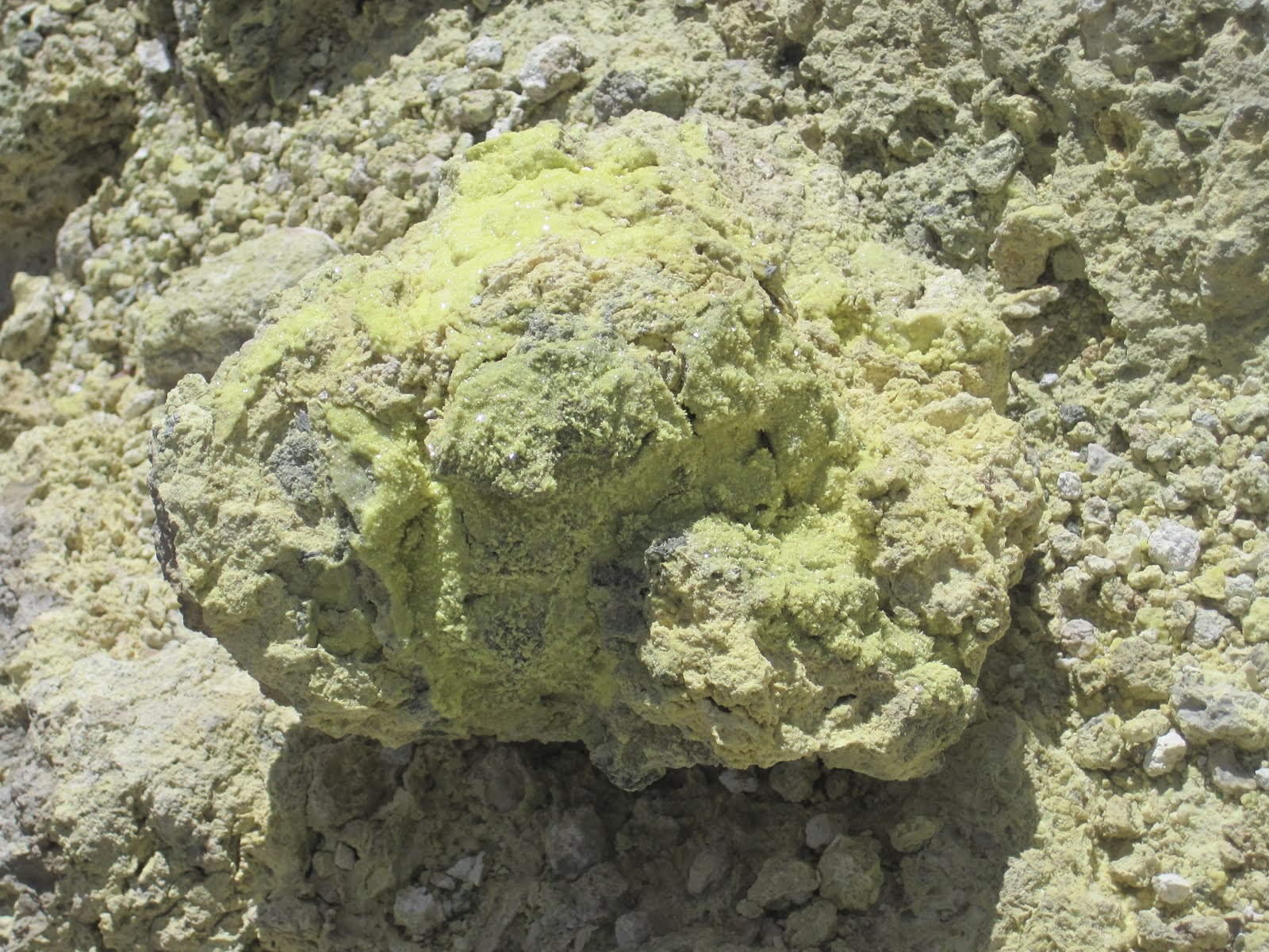
Sulfur crystal. You can kind of see it sparkling in the sunlight.
After they flow through the Valley of Desolation, the minerals all mix together and come out to be a more or less healthy blend of warm water and spa-like waters. There is a lovely series of waterfalls with bluish, milky water that lots of people bathe in on their way back from the Boiling Lake. The water is just a little cooler than a hottub and would have been nice to bathe in. We decided to push on and not risk relaxing our poor muscles before we reached the end of the hike!
The best thing about this kind of graffiti is that it will be gone in about 24 hours. The calcium build-up is so quick that this is truly non-destructive graffiti.
Another hematite-rich stream flowing down from above the Valley of Desolation and just before the Boiling Lake.
Scree! Not fun to walk on, and also not counted in the 4000 stairs. But it was worth it because right around the next hill was...
The Boiling Lake!
The Boiling Lake is either the largest or the second largest of its kind in the world, depending on your source. It's a crater lake, about 60 feet deep by about 200 feet in diameter, and the temperature is very hot (183F where the cool water from the waterfall, see below, enters the rest of the lake). It's stinky with sulfur, and the mists will sting your eyes, but it's very cool. Our guide, Jeffrey, had recently participated as a guide for a Canadian TV show called Angry Planet in which a foolish human had crossed the lake on a system of rope pulleys to test the temperature all the way across. The crew spent three days camping at the lake to get the footage. Jeffrey showed us the rocks they had used for anchors, and once again I was reminded of why it's a good thing to not be married to a daredevil. Points to Ian!
The famous cool-water waterfall.
The boiling spot of the Boiling Lake in action. Cool shots and steady hands courtesy of Ian.
And our photo together to prove we were there. Remember, Ian is squinting because of the insanely bright sun and the swirling sulfurous gases. It's allowed and even encouraged in these circumstances. After all, what's the point of evolving instincts and muscles to protect your eyes if you don't use them!
All along the floor of the Valley of Desolation, you can see a more stable environment taking root, literally in some cases. Mosses grow first, and when they die they become thin soil that weedy grasses can live in. Then the grasses die and small shrubs come up and so on. The entire island was devastated by Hurricane David in 1979, and much of the forest covering was lost completely. Obviously that's not connected to the geothermal activity in the Valley of Desolation, but it is all part of the same cycle of life. The forest is more or less recovered (though permanently changed) 34 years later, and plant life has re-asserted itself.
Jeffrey's leaf spring! Clean and delicious drinking water on the floor of the Valley of Desolation! And you'll want to refill here because you know what's coming....
It's the uphill slog, back up to the top of Morne Nicholl. Yep. It's 600-some stairs plus several creek beds, roots, and boulders to scramble up. This is the first leg of it.
Looking back down the second leg.
Looking back down the stairs we'd just climbed...
And finding some small comfort in the fact that Jeffrey too thought it was hard-going. Sad to say, but Ian and I independently were comparing the hike to the stairs into Mordor by the end.
To be fair, though, most of the stairs were quite idyllic and not at all like Mordor.
We saw a cute little snake on the way back. Dominica has no poisonous snakes (though there are boa constrictors), but this snake gives off a foul and lingering odor if you touch it.
And a cool lizard. There are lots of lizards - and not just geckos! - in Dominica!
The beginning and the end of the Boiling Lake trail is at a place called Ti Tou gorge. Ti tou means "little throat" in Creole, and even the guide books call this gorge claustrophobic. We didn't swim it, but apparently if you do, at the end of a hellishly narrow and dark gorge, you come to a lovely waterfall. Sounds just about awful to me, but we heard lots of people splashing and swimming in the waters both times we walked past.
Here's the little map of the hike! We started in Laudat (upper left) and went all the way to the Boiling Lake (middle right) and back! It's about six miles round trip, but the elevation variation is significant!
Champagne Reef is a popular snorkeling and diving site just south of Roseau on the western side of Dominica. It gets its name from the volcanic gases that push up through the rocks and create streams of bubbles that are not unlike the bubbles in champagne (except for the obvious differences salt water instead of champagne, and pleasantly warm instead of pleasantly crisp). It's a very popular site for tourists to come to off the cruise ships, and we were surprised by how quickly the organized tours cycled people through. You don't get to stay in a place like Champagne Reef very long if you're just in town for a day off a cruise ship.
There they are! The hoards of snorkeling cruisers!
Almost all of these pictures are taken by Ian because he loves it so much and is much more comfortable in the water than I am. Enjoy!
I really love brain coral!
He's amazing!
My safety yellow shirt is actually a floatation device. It makes me so much more comfortable in the ocean!
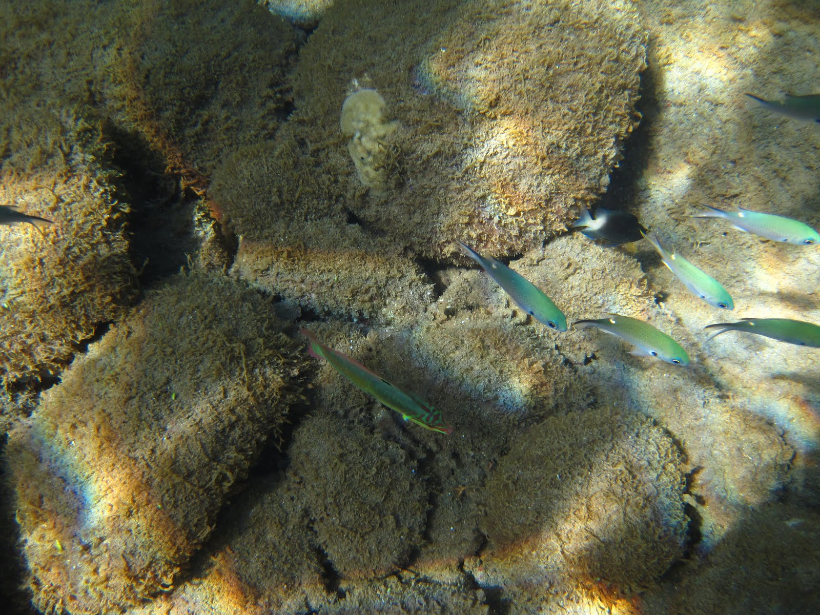
Cool fish!
And finally the bubbles! Turns out they're only right up against the shore, not spread throughout the whole reef.
The bubbles really were marvelous!
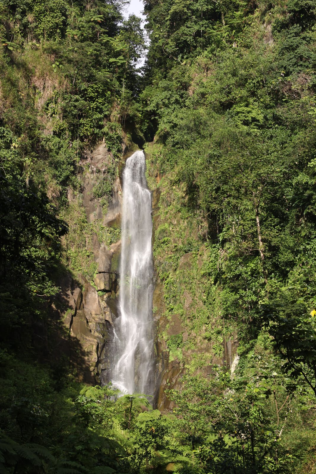
Trafalgar Falls is another major cruise ship destination. These are twin waterfalls towards the end of the Roseau Valley that fall almost in parallel into a massive boulder field below. I believe they join in the boulder field and go on to the sea together. In mid-afternoon, Trafalgar is mobbed with mini-buses and flip-flop wearing cruisers. After about 4PM, however, it's quiet, peaceful, and lovely.
The northern falls.
The southern falls.
And the romantic picture with the southern falls not visible in the background. Did I mention the light was intense?
As we were leaving Trafalgar in the evening, we experienced a very curious rainstorm. Rain on Dominica is not unusual - it's tropical, after all - but there were no clouds in the sky during this particular rainstorm. And it was not just mist moving quickly; it really looked and felt like a good, wet rain. Whatever the meteorological phenomenon (or not), it made a beautiful rainbow!
After Trafalgar we finally decided to give our muscles a break. The Trafalgar region is pockmarked with sulfur pools that have been developed into little spas, so we chose one of the oldest, paid our US$8 each, and went and sat in mineral-rich hot water for a couple of hours. The hot pool had a cool pool adjacent, and to make it even better, a waterfall.
Waiting for dinner that night, we met Marcos and Sabine, and we learned about their new restaurant and its wood-oven pizza. We headed there a few nights later for dinner, and it was excellent! They make delicious pizza, and Sabine mixes the best rum punch I've had so far. If you're in Roseau for dinner, we both highly recommend looking up Sunshine Cottages and the Wood-Oven Pizza!
Dominica is home to two types of parrots, the Sisserou and the Jaco. The Sisserou parrot is endangered and the Jaco is quite rare, so Dominica has a couple of special parrot places. We visited the Syndicate Parrot Reserve and took a short hike, but it's mating season and so we didn't see any parrots. We did hear some, we think.
Ian gives scale with a chataigner tree. They grow tall and have big, wide buttress-like trunks, but they have no tap root and are actually pretty unstable.
Here's the same tree, no Ian, slightly wider view. I love these trees.
There we are!
There are some really great signs in Dominica!
For my Creole-speaking friends, this is, of course, fly's wing. It's a beautiful big leafy plant. Most of the common names for plants in Dominica seem to be in Creole rather than English, but our guides seemed to have a pretty strong Latin base as well. Somebody suggested it's because of the English influence and the traditional English love of gardens: English tourists were not satisfied with local names!
When we were planning our trip, we wanted to do two big hikes, the Boiling Lake and the Morne Diabolitin. The Lonely Planet makes the Morne Diabolitin trail sound grueling but totally worthwhile. Local expertise, however, makes it sound like a grueling slog with no view, only a little variety for the bulk of the hike, and a strong possibility that the top will be shrouded in clouds, meaning no view after all that unrewarding work. We had already backed out of the hike when we saw this sign at the trailhead!
After a short and easy walk at the Parrot Reserve, we had lunch on Prince Rupert Bay, one of the island's very few white sand beaches. Portsmouth is the city on Printe Rupert Bay, and it's supposedly quite a lovely town. There are loads of fancy sailboats and yachts that come into harbor here, so it's a pretty posh crowd.
This is a view of the Cabrits Peninsula and Fort Shirley (see the next entry) from the southern side of the bay.
Here are some of the posh sailboats. There were some English sailors (the posh kind, not traditional limeys) in the bar, and it was interesting at first to listen to their gossip!
Prince Rupert Bay is obviously not only for pleasure boats! This is clearly a working boat.
We waited about 90 minutes for a fish-n-chips lunch at a Lonely Planet-recommended restaurant on the waterfront. Luckily they brought us big passionfruit juices right away. This picture is from before we had waited an unconscionably long time.
After lunch we took a rowboat tour up the Indian River. We were sitting quite close together, so Ian thought he'd be silly and take a close-up of my face. I like it that you can see him reflected in my glasses.
Heading up the Indian River. We're in a pink rowboat very similar to the yellow one you can see.
More ferns!
This is wild hibiscus with both orange and yellow flowers.
This is wild sugarcane growing in among the palm trees. It's not productive - you couldn't get sugar from it - but it's pretty!
This little red-headed duck fled into the brush when she saw us coming.
The Indian River winds through a white mangrove. The afternoon light was just about perfect for reflections, and I took a lot of pictures. Parts of the Pirates of the Caribbean (2 and 3, I think) were filmed on Indian River (and throughout Dominica), so we'll have to watch the series again to see what we can recognize.
The end of the boat ride is a funky bush bar that serves a rum punch nicknamed "Dynamite." Ironically, the bar is also accessibly via a ten-minute walk up a nice path, but you wouldn't know that from how isolated the boat ride feels!
This is Dominica's flag with the parrot emblem.
And the bar had a garden with lovely flowers.
Our river guide and rower was Friday. I couldn't decide which picture I liked better, so you get them both!
Say what you will, Dominicans take a lot of pride in their country and in their infrastructure. Most of the operators of large tourist sites and some of the hotels seem to feel that cruise ships are a necessary evil, but once you're off the cruise ship paths, it's a very easy and laid back place to visit.


That lake is *stunning*...
ReplyDelete