Sunday, March 27, 2011

Chiapas IV: Palenque

On our last morning we went to the ruins at Palenque. These are the most accessible and the most visited of the three we saw, but even so, the crowds were not overwhelming!


Here we are, the intrepid tourists! This is at Palenque; behind my mother is the Temple of Inscriptions, and behind Ian is the Palace complex.


The map of Palenque. Sadly, parts of it were closed, but we still tromped up and down and had a good time. It was blazing hot, and the sun felt much stronger than it had in the other two ruins. The place was overrun with tourists - mostly French - who were having to walk quite a way to get to the entrance because there was a great big hole in the road that prevented buses from getting past. To give credit where credit is due, they climbed all the ruins and listened to their guides after that long, hot walk!


Palenque, as seen from the top of the Temple of the Cross. The ruins are situated in the first string of hills above the flat plain that is now northern Chiapas and Tabasco states. Straight north lies the Gulf of Mexico.


The Temple of Inscriptions. It was off-limits for climbing, but it's part of the iconic view of Palenque.


This is the Palace complex seen from above. The double arch (see photo below) is behind the trees in the lower right corner. The Palace has an underground series of rooms and halls that is open for exploration as well as sunken plazas and the square observation tower.


This is an awesome double arch feature in the Palace pyramid complex. This is a must-have for any house Ian and I might eventually buy or build.


The Dali-was-here steps up to a temple group across the plaza from the main buildings.


A small temple near the Temple of the Cross. It had awesome views of the site even though the approach was not the easiest. It had interesting glyphs and carvings at the top.


The steps up the Temple of the Cross. They're very steep - it's not just the angle!


Ian and I demonstrate the size of this tree. The trees are impressively huge, and the thin soil causes their roots to curl around above ground wonderfully.


This ruin had passages with stairs connecting what now appears to be the roof with the ground floor. Note the size of the steps, and remember that these were small people (based on both knowledge that they were small and empirical evidence in the height of the ceilings).


I love seeing the power of the jungle to reclaim its space! The excavation of the Palenque ruins took tremendous effort, and the effort is ongoing to keep the jungle at bay.


The "Queen's Bath" waterfalls, below the main site of Palenque, were so beautiful they looked fake. Pools of water, long chutes, trickles down the rocks, and tons of vegetation made this spot amazing after the blazing sunlight and heat of the upper parts of the ruin. Near this site are what were probably residential zones. The contrast between the larger-than-life commercial and religious areas and the residential spaces is astounding.

-----

No trip to the jungle is complete without the hopelessly exotic flower pictures. These were, true to form, growing in the garden at the entry to the site.


Chiapas III: Bonampak

At the end of the day, we headed to Bonampak, deep within the Lacondon jungle. It is a small site, but it has original paintings on the roofs and walls in a three-room temple. We had a lovely guide show us the sites and consequently learned quite a lot about the area.


The left-hand temple, halfway up the pyramid at Bonampak. The right-hand temple has three original paintings on its walls, showing the naming of a successor, a major battle with an unidentified enemy, and the victory celebration. Apparently the paintings were made towards the end of Bonampak's glory days, and when the site was abandoned (circa 900 CE), water leached a mineral down over the paintings and a protective mineral build-up kept the paintings safe from the ravages of the jungle for 1000 years. They were found, naturally, by accident in the late 1990s, and the exposure to the jungle air is damaging them. The reconstruction of the paintings and their meaning is astounding.


Bonampak is in a part of the world known as the Lacondon jungle (selva lacondona). The people who live in the area are the Lacondon group, and this is a traditional outfit: shapeless and long. The adults seem to wear white, but this young girl was in brilliant purple. (She was posing for another photographer, so this photo in no way damaged her soul.) Most of the Lacondon we saw in the area had long, loose hair and wide mouths. They run the area and the tourist site but receive little federal support for maintenance, according to our guide.


Stela #2 shows a marriage ceremony between the governor of Bonampak and a princess from Yaxchilan, a union that united the two cities. The governor's mother is also in the carving in front of the governor. She is pricking his finger and collecting the blood in a a bowl (carried by the princess behind the governor) to encourage fertility in the relationship and in the earth. The stela shows obsidian and conch shells - both foreign materials - that attest to the powerful trading center that Bonampak was. The glyphs at the top-right describe the images.


Stela #3: dealing with a powerful prisoner, if I'm not mistaken. Romance about lost civilizations is jolly, but the Maya were not kind to the vanquished.


Looking down at the well-tended grounds of Bonampak from the pyramids. It was about 4.00, and everything was golden.


Bonampak abuts a biological preserve, and these parts, above and behind the main complex, remain un-excavated.


This is the runway that was once the only easy access to Bonampak. Now there's a highway, thank goodness, because the price of flying in made the visit hard to justify!


On the way home from Bonampak, shortly before stopping at our second Zapatista roadblock, we came across this badly wounded boa constrictor. Presumably it's a wild animal (as opposed to a pet), but it was barely moving and barely breathing. I stayed in the van; Ian and my mother heroically got out for pictures.

Chiapas II: Yaxchilan

On Tuesday (March 22) we went with a tour to ruins outside of Palenque called Yaxchilan and Bonampak (see previous post). Yaxchilan is on a spur of land in the Usumacinta river and can only be reached by boat.


These are the boats we rode up the river! The Usumacinta river is the border between Mexico and Guatemala: on the near side (where the boats are) it's Mexico; on the far side, it's Guatemala. This border is described as "porous" by people who work on immigration issues, and from this photo it's clear to see why!


Awesome root system on this tree. Chiapas' rainy season starts in late April, so the river will probably get bigger in short order!


Egret on the water.


The map of Yaxchilan at the entry. The site was active and populated from around 600 CE until around 800 CE, according to archaeologists. Because of its location, i.e., on a big river that reaches the Gulf of Mexico, it was probably a powerful trading and religious center.


Semi-buried and partially restored buildings at Yaxchilan.


A standard ruined interior of a small temple. I believe from reading the explanation posted that this ceiling is in "trilobulate" architecture. If trilobulate is truly a word in English (haven't looked it up yet), it is on its way to joining defenestrate among my favorite words. Presumably it means peaked but with a flat plane at the top, as most of these roofs are. If it's just a mistake in translation, c'est la vie and I'll wait for another new favorite word.


This is one of the stelae that remains. It shows probably a governor or other ruler of Yaxchilan with symbols of power around him. At the bottom are 12 glyphs (the boxy figures at the base of the stela) explaining the story.


Incomplete excavation on the remains of a temple. It's easy to see how the jungle gobbled the ruins over 1000 years and left them disguised as hills!


The temple at the top of the highest pyramid. Note the central statue of a person with only one leg. Yaxchilan is known for its carvings and sculptures.


Looking down the steep stairs to the highest Yaxchilan pyramid. Note the trees growing in the stairs - it must have looked so different when it was an active community.


On our way to the small acropolis, where we saw...


Howler monkeys!! We'd been hearing them all morning, and rounding a corner on our way to the small acropolis we saw them. Five or six were moving around in the trees, playing and wrestling with each other. Kudos to Ian for taking the pictures!


Monkey! I love how its fingers are so visible and how it's just sitting on the branch, resting.


Happy boy saw monkeys!! Too bad he wasn't wearing the sting ray shirt.


The small acropolis seen from below.


The top of the small acropolis. There was nobody else there, just the sound of the howler monkeys and random birds. It was great.


The equivalent of the maple tree's helicopter seed from a ceiba tree. Those trees are awesome!


Probably a shoot for a ceiba tree, but I'm not sure.

Chiapas I: San Cristobal de las Casas and Surrounding Villages

On Saturday (March 19) Ian, my mother, and I flew to Tuxtla Gutierrez, Chiapas, and then took a taxi up the old, pretty road to San Cristobal de las Casas. Saturday afternoon we explored San Cristobal: the amber museum, the indigenous culture museum, and the pedestrian streets in the city. Chiapas is one of a handful of places in the world that produce amber, and it's the only (so they claim) place that produces red amber (gorgeous!). The amber museum was the perfect size and had a great balance between samples with magnifying glasses and lights to enhance them and descriptive explanation. The English version (obtained by my mother) claimed that amber must be mined in shorts, as in what the miners must wear, but we found nothing like it on the walls in Spanish.


Lovely San Cristobal de las Casas, an important Spanish city in colonial days, and a wonderful place to visit now. It is high in the mountains - around 7000 feet above sea level - and nestled in a bowl.


San Cristobal has lovely pedestrian streets, mobbed with people, and is surrounded by steep, green hills.


San Cristobal's cathedral. On Saturday there was a rap/ rock concert held on the porch, and on Sunday another smaller concert held in the plaza. Last July my driver told me that in the 1970s a nearby indigenous village, San Juan Chamula (see below), is reported to have expelled residents who were insufficiently indigenous or who practiced a different religion. The internally displaced people flooded San Cristobal, and the diocese of San Cristobal broadened its tenets to incorporate and welcome the refugees.


The del Carmen arch, built in 1677, marks the end of one of the pedestrian streets.


Detail of the underside of the del Carmen arch.


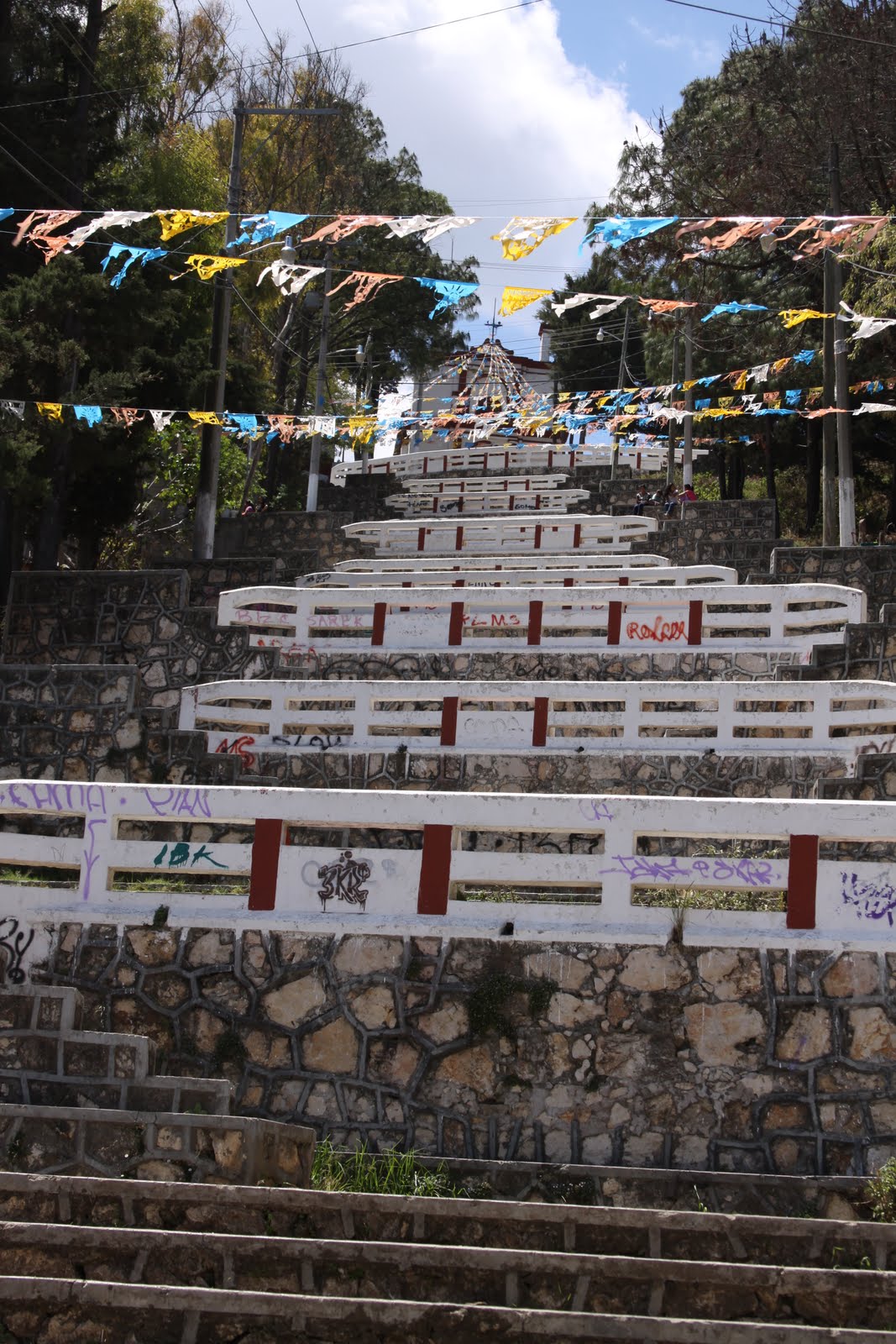
A festive climb up a steep, tiered staircase to a nice view of San Cristobal!


This little church has a good view of San Cristobal and an outdoor exercise facility at the top of the stairs.


The ubiquitous balloon seller. This individual is cloned for every city plaza in Mexico!

-----


On Sunday we hired a taxi and driver and headed out into the villages around San Cristobal. Sunday is market day, and the villages have strong indigenous traditions. Our driver was a great balance of information and reticence: he answered all the questions but didn't chatter at us all day long. The countryside around San Cristobal is quite poor, but it is also very beautiful. This is a village cemetery. Apparently there had recently been a fiesta that involved setting up tables in the graveyard, hence the mounds of fresh earth and planks. They are not fresh graves, despite appearances. Also stunning are the crosses in the trees.


On the way in to Tenejapa we passed this interesting saddle mountain.


In contrast with the photo below, these houses are clinging to a fairly steep slope. The poor in Chiapas have been pushed into these areas, though, to be fair, many have an ancestral tie with the land. The pushing was done centuries ago.


Chiapas is a topographically difficult state. The areas around San Cristobal are deep, narrow valleys and steep hills.


Our first stop was Tenejapa (ten-eh-HOP-ah), about 30 minutes northeast of San Cristobal. The food market was hopping, and there were about 60 people queued up in front of an administration building to receive their subsidies from a highly controversial agricultural support program. This is the church, but inside it is under repairs and didn't look too good. Note the man in traditional dress in the corner of the photo: they wore bright red shorts and white cotton blouses covered by great felted (?) black wool tunics. The felting process makes the wool look like bearskin. Women's skirts are often made of the same material in other parts of the region.


The cliffs around Tenejapa were striking.


Our second stop was Amatenango, about an hour southeast of San Cristobal. Amatenango specializes in pottery. On the highway there is a pull-out with about a dozen sidewalk type shops selling the wares. All the shops were attended by women; men were very seldom around the tourist industry sites (Migration? Field work? Hard to say, but there were very few boys either.)


Amatenango has all the bird- and animal-themed kitsch you never knew you needed. Note especially the napkin holders. I was sorely tempted. Ian got a very cool jaguar mask to go on our mask wall.


Lots of doves and pigeons! We bought a pair of peacocks that were clearly conceived by the same potter....


Our third village was Zinacantan. Like its neighbor, San Juan Chamula (see below), Zinacantan is very traditional. Unlike San Juan Chamula, however, Zinacantan embraced government development programs and is considerably wealthier than other villages. It produces flowers and is recognizable by the greenhouses filling its valleys and climbing its hillsides like reverse glaciers. We only visited one shop in Zinacantan, and it had a bit of everything. My mother is checking a skirt and deciding to use it as a tablecloth. The traditional women's dress in this area is a skirt (about two yards of fabric in a solid loop, doubled over in front to make the right size, and held up with a wide cloth belt), a blouse with embroidery, and a shawl like the one in the photo below. Most of the skirts are cotton and finely embroidered like these, but some women wear the traditional loosely felted (?) wool skirts. They look like bear skins and must be extremely itchy.


I love these shawls! I tried one on in July and decided it was too elegant for me. As soon as I turned away from the young woman selling them, I was mobbed by little girls in traditional wear selling gum and candy. Guess what, they were all wearing the shawls and skirts and running around barefoot. I doubt I wear it with a fleece and cargo pants, but it might be perfect over a little black dress somewhere!


San Juan Chamula is a village about 30 minutes out of San Cristobal with a very strong indigenous culture. Residents cannot be photographed, and many wear traditional garb. Ironically, to help combat serious problems with alcohol abuse, Coke and Pepsi were introduced to the culture in recent years and now feature prominently in local culture and traditions. The church looks Catholic from the outside but is actually an uneasy blend of Catholic and pre-Catholic traditions. The floor is thick with fresh pine needles, there are no pews or seats, patron saints of the surrounding villages line the walls, and shamans (for lack of a better word) sway over groups of candles on the floor, chanting and intoning. The saints all live in glass containers, ready to be carried in processionals, and they all wear mirrors around their necks. A previous guide claimed that was to "reflect the clarity." Possibly because it was Sunday, the church was alive with candles, and several family groups were engaged in private ceremonies, blessing new babies and the like. The last time I was there (July 2010), two chickens were sacrificed while I was in the church (maybe within 10 minutes). A couple of chickens were headed in as we headed out. Photos are not allowed in the church.

The famous church, as seen from the outside. The three colors around the door and upper window represent San Juan, San Pedro, and San Jose Chamula, the three most important communities.